NASA Logo, National Aeronautics and Space Administration

National Aeronautics and Space Administration

Goddard Space Flight Center

ALT

Fire Energetics and Emissions Research

FEER Updates

RSS

20.Feb.2019 - VIIRS active fire data available as VNPFIRE product.

12.Feb.2019 - FEERv1.0 Emissions processing stream fixed.

08.Feb.2019 - MODFIRE processing stream fixed.

31.Jul.2018 - Suomi-NPP VIIRS fire data added to Africa Explorer.

Validation of the MODIS Fire Radiative Power Product

Current collections/versions of the MODIS Level 2 FRP product (MOD14/MYD14) have not yet been validated. Validation of this product shall be conducted using both an internal analysis between coincident data of the same fires between Terra and Aqua, and using airborne data to compare with MODIS measurements. Any resulting algorithm will be incorporated into a production of new data files to be made available in the data section of this website.

Duplicate MODIS Fire Detections

Bowtie_effect_and_algorithm.png

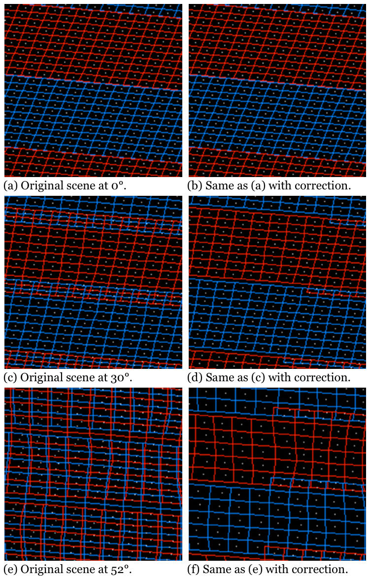
Figure 1: MODIS scans (shown in alternating colors) overlap each other due to the “bow-tie” effect. A general algorithm can remove these overlapping pixels.

Multiple fire detections are often made of the same fire in subsequent MODIS scans due to the “bow-tie” effect, or rather, the fact that a given detector covers greater ground area off-nadir. Since FRP measurements are not gridded data but are rather distinct data points, this is an issue that most always needs to be dealt with in the following analyses.

Duplicate_fire_deletion_method_verification.png

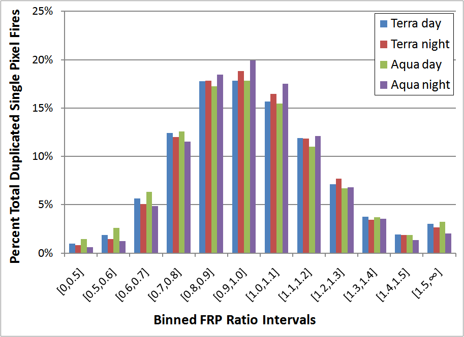
Figure 2: FRP ratios of identical fires measured on subsequent scans are binned as shown to intervals of 0.1 for all single-pixel fires in the years 2003-2009.

A general algorithm to remove duplicate fires was developed that is not dependent on any specific fire pixel's characteristics but rather was derived using assumptions of a perfectly smooth Earth surface so that it can be applied to a set of fire data based on a pixel's location within a granule instead of its position on the Earth. Table 1 shows what fires fall within the valid range of sample indices of a MODIS granule, and Figure 1 shows the effect of applying this algorithm to a section of overlapping MODIS pixels. In order to check the validity of applying this general algorithm to MODIS fire data, single-pixel fires' FRP values were compared against their duplicate values and these ratios were binned into 0.1 intervals as shown in Figure 2. The resulting bell shaped curve implies that, generally speaking, it is acceptable to simply remove a “random” duplicate fire pixel using this algorithm.

Track # of Scan 0 1 2 3 4 5 6 7 8 9
Table 1: Considering a MODIS scan having a width of 10 pixels along track, the range of sample indices (along scan) that do not overlap by at least half a pixel with the previous scan are recorded here for a given track number.
Valid Range (sample) 465-888 199-1154 111-1242 35-1318 0-1353 0-1353 0-1353 0-1353 0-1353 308-1045
Equivalent Scan Angles ±17.2° ±38.8° ±46.0° ±52.1° ±55.0° ±55.0° ±55.0° ±55.0° ±55.0° ±29.9°

FRP Measurement Variability

FRP_comparisons_between_Terra_and_Aqua.png

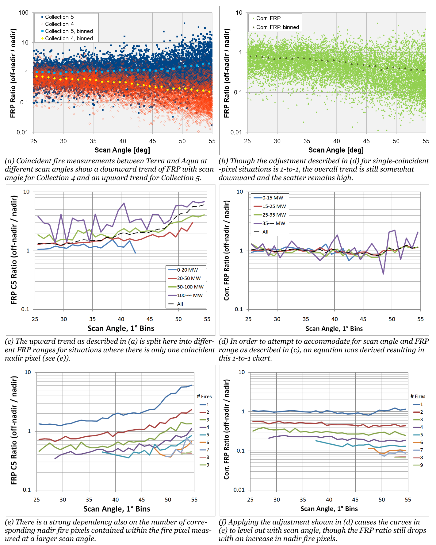
Figure 4: Comparisons between Terra and Aqua FRP measurements are shown above. Single-pixel fires at larger scan angles are compared with the sum of corresponding nadir FRP values of the same fire measured by the other satellite. Collection 5 values are shown in the leftmost column, and adjusted values based on an equation dependent on scan angle and FRP are shown on the right.

When Collection 5 was created, which incorporates the pixel area term into Collection 4 data so as to get true power measurements, the difference became apparent when plotting FRP over different scan angles (see Figure 3). The flatness of the min FRP Collection 4 curve is characteristic of the fact that there exist certain cutoff values in the fire determination algorithm that are constant. Currently the plan for the Collection 6 fire algorithm is to make these constant values vary according to scan angle. Consequently, because the area term is incorporated into Collection 5 FRP values but not in the fire determination algorithm, there exists a tendency for Collection 5 FRP to be higher off-nadir than at nadir.

Min_FRP_vs_SA.png

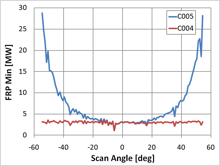
Figure 3: Minimum FRP values are shown here verses scan angle for Collection 4 (without an area term) and Collection 5 (with an area term).

A more in depth analysis is being done to determine the true extent of FRP measurement variability in Collection 5. This has so far mostly been an internal analysis based on comparisons between MODIS on Terra and MODIS on Aqua over the same fires and measured within 20 minutes (corresponding to a lower limit of 53° latitude.) The effects that some of the different variables have on FRP measurements are shown in the first column of Figure 4. An effort was made to derive a variable factor, dependent on scan angle and FRP using comparisons of single-pixel fires, so that when multiplied against FRP values measured at larger scan angles, its adjusted FRP value will match the corresponding near-nadir measurement. The results for these adjusted FRP values are shown in the second column of Figure 4.

Supporting Documents

AGU 2010 Fall Meeting
Detailed Analysis of the EOS-MODIS Instrument's Fire Radiative Power Product
[poster]

Publications

Dickinson, M. B., Hudak, A. T., Zajkowski, T., Loudermilk, E. L., Schroeder, W., Ellison, L., … Mauceri, J. (2016). Measuring radiant emissions from entire prescribed fires with ground, airborne and satellite sensors – RxCADRE 2012, Supplementary material. International Journal of Wildland Fire, 25(1). doi:10.1071/WF15090_AC

Ichoku, C., Kaufman, Y. J., Giglio, L., Li, Z., Fraser, R. H., Jin, J.-Z., and Park, W. M. (2003). Comparative analysis of daytime fire detection algorithms using AVHRR data for the 1995 fire season in Canada: Perspective for MODIS. International Journal of Remote Sensing, 24(8), 1669–1690. doi:10.1080/01431160210144697

Ichoku, C., Giglio, L., Wooster, M. J., and Remer, L. A. (2008). Global characterization of biomass-burning patterns using satellite measurements of fire radiative energy. Remote Sensing of Environment, 112(6), 2950–2962. doi:10.1016/j.rse.2008.02.009

Ichoku, C., Kahn, R., and Chin, M. (2012). Satellite contributions to the quantitative characterization of biomass burning for climate modeling. Atmospheric Research, 111, 1–28. doi:10.1016/j.atmosres.2012.03.007

Peterson, D., Wang, J., Ichoku, C., Hyer, E., and Ambrosia, V. (2013). A sub-pixel-based calculation of fire radiative power from MODIS observations: 1. Algorithm development and initial assessment. Remote Sensing of Environment, 129, 262–279. doi:10.1016/j.rse.2012.10.036

Polivka, T. N., Wang, J., Ellison, L. T., Hyer, E. J., and Ichoku, C. M. (2016). Improving Nocturnal Fire Detection With the VIIRS Day–Night Band. IEEE Transactions on Geoscience and Remote Sensing, 54(9), 5503–5519. doi:10.1109/TGRS.2016.2566665


References

Csiszar, I. a., Morisette, J. T., and Giglio, L. (2006). Validation of active fire detection from moderate-resolution satellite sensors: the MODIS example in northern eurasia. IEEE Transactions on Geoscience and Remote Sensing, 44(7), 1757–1764. doi:10.1109/TGRS.2006.875941

Csiszar, I., Schroeder, W., Giglio, L., Ellicott, E., Vadrevu, K. P., Justice, C. O., and Wind, B. (2014). Active fires from the Suomi NPP Visible Infrared Imaging Radiometer Suite: Product status and first evaluation results. Journal of Geophysical Research: Atmospheres, 119(2), 803–816. doi:10.1002/2013JD020453

Dozier, J. (1981). A method for satellite identification of surface temperature fields of subpixel resolution. Remote Sensing of Environment, 11, 221–229. doi:10.1016/0034-4257(81)90021-3

Elvidge, C. D., Ziskin, D., Baugh, K. E., Tuttle, B. T., Ghosh, T., Pack, D. W., … Zhizhin, M. (2009). A Fifteen Year Record of Global Natural Gas Flaring Derived from Satellite Data. Energies, 2(3), 595–622. doi:10.3390/en20300595

Freeborn, P. H., Wooster, M. J., Roy, D. P., and Cochrane, M. A. (2014). Quantification of MODIS fire radiative power (FRP) measurement uncertainty for use in satellite-based active fire characterization and biomass burning estimation. Geophysical Research Letters, 41(6), 1988–1994. doi:10.1002/2013GL059086

Giglio, L., and Justice, C. O. (2003). Effect of wavelength selection on characterization of fire size and temperature. International Journal of Remote Sensing, 24(17), 3515–3520. doi:10.1080/0143116031000117056

Giglio, L. (2015). MODIS Collection 6 Active Fire Product User’s Guide (A.). Retrieved from http://modis-fire.umd.edu/files/MODIS_C6_Fire_User_Guide_A.pdf

Giglio, L. (2013). MODIS Collection 5 Active Fire Product User’s Guide (2.5.). Retrieved from http://modis-fire.umd.edu/files/MODIS_Fire_Users_Guide_2.5.pdf

Giglio, L., Csiszar, I., and Justice, C. O. (2006). Global distribution and seasonality of active fires as observed with the Terra and Aqua Moderate Resolution Imaging Spectroradiometer (MODIS) sensors. Journal of Geophysical Research, 111(G2), G02016. doi:10.1029/2005JG000142

Giglio, L., Descloitres, J., Justice, C. O., and Kaufman, Y. J. (2003). An Enhanced Contextual Fire Detection Algorithm for MODIS. Remote Sensing of Environment, 87(2–3), 273–282. doi:10.1016/S0034-4257(03)00184-6

Giglio, L., Schroeder, W., and Justice, C. O. (2016). The collection 6 MODIS active fire detection algorithm and fire products. Remote Sensing of Environment, 178, 31–41. doi:10.1016/j.rse.2016.02.054

Hawbaker, T. J., Radeloff, V. C., Syphard, A. D., Zhu, Z., and Stewart, S. I. (2008). Detection rates of the MODIS active fire product in the United States. Remote Sensing of Environment, 112(5), 2656–2664. doi:10.1016/j.rse.2007.12.008

Justice, C. O., Giglio, L., Korontzi, S., Owens, J., Morisette, J. T., Roy, D., … Kaufman, Y. (2002). The MODIS fire products. Remote Sensing of Environment, 83(1–2), 244–262. doi:10.1016/S0034-4257(02)00076-7

Justice, C. O., Vermote, E., Townshend, J. R. G., Defries, R., Roy, D. P., Hall, D. K., … Barnsley, M. J. (1998). The Moderate Resolution Imaging Spectroradiometer (MODIS): land remote sensing for global change research. IEEE Transactions on Geoscience and Remote Sensing, 36(4), 1228–1249. doi:10.1109/36.701075

Justice, C., Giglio, L., Boschetti, L., Roy, D., Csiszar, I., Morisette, J., and Kaufman, Y. (2006). MODIS Fire Products Algorithm Technical Background Document (2.3.). Retrieved from http://modis-fire.umd.edu/AF_usermanual.html

Kaufman, Y. J., Justice, C. O., Flynn, L. P., Kendall, J. D., Prins, E. M., Giglio, L., … Setzer, A. W. (1998). Potential global fire monitoring from EOS-MODIS. Journal of Geophysical Research, 103(D24), 32215–32238. doi:10.1029/98JD01644

King, M. D., Menzel, W. P., Grant, P. S., Myers, J. S., Arnold, G. T., Platnick, S. E., … Osterwisch, F. G. (1996). Airborne Scanning Spectrometer for Remote Sensing of Cloud, Aerosol, Water Vapor, and Surface Properties. Journal of Atmospheric and Oceanic Technology, 13(4), 777–794. doi:10.1175/1520-0426(1996)013<0777:ASSFRS>2.0.CO;2

Kumar, S. S., Roy, D. P., Boschetti, L., and Kremens, R. (2011). Exploiting the power law distribution properties of satellite fire radiative power retrievals: A method to estimate fire radiative energy and biomass burned from sparse satellite observations. Journal of Geophysical Research, 116(D19), D19303. doi:10.1029/2011JD015676

Li, F., Zhang, X., Kondragunta, S., and Roy, D. P. (2018). Investigation of the Fire Radiative Energy Biomass Combustion Coefficient: A Comparison of Polar and Geostationary Satellite Retrievals Over the Conterminous United States. Journal of Geophysical Research: Biogeosciences, 123(2), 722–739. doi:10.1002/2017JG004279

Luo, R., Hui, D., Miao, N., Liang, C., and Wells, N. (2017). Global relationship of fire occurrence and fire intensity: A test of intermediate fire occurrence-intensity hypothesis. Journal of Geophysical Research: Biogeosciences, 122(5), 1123–1136. doi:10.1002/2016JG003722

MODIS Characterization Support Team. (2006). MODIS Level 1B Product User’s Guide (No. M1054) (5.0.). Greenbelt, MD.

Morisette, J. T., Giglio, L., Csiszar, I., and Justice, C. O. (2005). Validation of the MODIS active fire product over Southern Africa with ASTER data. International Journal of Remote Sensing, 26(19), 4239–4264. doi:10.1080/01431160500113526

Morisette, J. T., Giglio, L., Csiszar, I., Setzer, A., Schroeder, W., Morton, D., and Justice, C. O. (2005). Validation of MODIS Active Fire Detection Products Derived from Two Algorithms. Earth Interactions, 9(9), 1–25. doi:10.1175/EI141.1

Oertel, D., Briess, K., Halle, W., Neidhardt, M., Lorenz, E., Sandau, R., … Brueggemann, H. (2003). Airborne forest fire mapping with an adaptive infrared sensor. International Journal of Remote Sensing, 24(18), 3663–3682. doi:10.1080/0143116021000033267

Oliva, P., and Schroeder, W. (2015). Atmospheric correction of VIIRS and MODIS fire radiative power retrievals for multi-sensor comparison. In 2015 IEEE International Geoscience and Remote Sensing Symposium (IGARSS) (pp. 2038–2040). IEEE. doi:10.1109/IGARSS.2015.7326200

Peterson, D. (2012). Retrieval of Sub-Pixel-Based Fire Intensity and its Application for Characterizing Smoke Injection Heights and Fire Weather in North America. University of Nebraska - Lincoln. Retrieved from http://digitalcommons.unl.edu/geoscidiss/30/

Peterson, D., and Wang, J. (2013). A sub-pixel-based calculation of fire radiative power from MODIS observations: 2. Sensitivity analysis and potential fire weather application. Remote Sensing of Environment, 129, 231–249. doi:10.1016/j.rse.2012.10.020

Schroeder, W., Csiszar, I., Giglio, L., Ellicott, E., Schmidt, C. C., Hoffman, J. P., and Lindstrom, S. (2010). Early characterization of the active fire detection products derived from the next generation NPOESS/VIIRS and GOES-R/ABI instruments. In 2010 IEEE International Geoscience and Remote Sensing Symposium (pp. 2683–2686). IEEE. doi:10.1109/IGARSS.2010.5650863

Schroeder, W., Csiszar, I., Giglio, L., and Schmidt, C. C. (2010). On the use of fire radiative power, area, and temperature estimates to characterize biomass burning via moderate to coarse spatial resolution remote sensing data in the Brazilian Amazon. Journal of Geophysical Research, 115(D21), D21121. doi:10.1029/2009JD013769

Schroeder, W., Prins, E., Giglio, L., Csiszar, I., Schmidt, C., Morisette, J., and Morton, D. (2008). Validation of GOES and MODIS active fire detection products using ASTER and ETM+ data. Remote Sensing of Environment, 112(5), 2711–2726. doi:10.1016/j.rse.2008.01.005

Wooster, M. J. (2003). Fire radiative energy for quantitative study of biomass burning: derivation from the BIRD experimental satellite and comparison to MODIS fire products. Remote Sensing of Environment, 86(1), 83–107. doi:10.1016/S0034-4257(03)00070-1

Wooster, M. J., Roberts, G., Perry, G. L. W., and Kaufman, Y. J. (2005). Retrieval of biomass combustion rates and totals from fire radiative power observations: FRP derivation and calibration relationships between biomass consumption and fire radiative energy release. Journal of Geophysical Research, 110(D24), D24311. doi:10.1029/2005JD006318

Xiong, J., Toller, G., Chiang, V., Sun, J., Esposito, J., and Barnes, W. (2005). MODIS Level 1B Algorithm Theoretical Basis Document (3rd ed.).

Xiong, X., and Chang, T. (2009). Performance of MODIS thermal emissive bands on-orbit calibration algorithm. In 2009 IEEE International Geoscience and Remote Sensing Symposium (p. III-271-III-274). IEEE. doi:10.1109/IGARSS.2009.5417754

Xiong, X., Chiang, K., Guenther, B., and Barnes, W. L. (2003). MODIS thermal emissive bands calibration algorithm and on-orbit performance. In H.-L. Huang, D. Lu, and Y. Sasano (Eds.), Proc. of SPIE … (pp. 392–401). doi:10.1117/12.466083

Xu, W., Wooster, M. J., Kaneko, T., He, J., Zhang, T., and Fisher, D. (2017). Major advances in geostationary fire radiative power (FRP) retrieval over Asia and Australia stemming from use of Himawari-8 AHI. Remote Sensing of Environment, 193, 138–149. doi:10.1016/j.rse.2017.02.024

Zhukov, B., Lorenz, E., Oertel, D., Wooster, M., and Roberts, G. (2006). Spaceborne detection and characterization of fires during the bi-spectral infrared detection (BIRD) experimental small satellite mission (2001–2004). Remote Sensing of Environment, 100(1), 29–51. doi:10.1016/j.rse.2005.09.019